San Francisco’s famous Fillmore jazz lounge and hotel was lost to urban redevelopment. Where was it?

The Booker T. Washington Hotel turns up in most accounts of San Francisco’s postwar “Harlem of the West” era. It was a six-story hotel off of Fillmore Street, a mainstay for Black musicians coming to the city to perform. In a time when downtown hotels often had segregationist policies, it was also a destination for Black celebrities.
Among the luminaries who stayed or even played there were Duke Ellington, the Nat King Cole Trio, Dinah Washington, James Brown, and writers and intellectuals W.E.B. DuBois and Langston Hughes.
The Booker T, as it was known, opened in 1951. By 1970, it was gone, demolished as part of San Francisco’s blithe “slum clearance” redevelopment project that wiped the old Fillmore literally off the map.
A personal interest in music, the history of music and of San Francisco led me to wonder: if I wanted to visit the spot where the hotel had stood, where would I go?
The Booker T. stood at 1540 Ellis Street, but that address doesn’t exist anymore.
San Francisco’s Western Addition is so-called because it was a westward expansion (to Divisadero) of the earlier boundary of the city (which ended at Larkin). That was in 1856 and encompassed a large area. The part of the city referred to today as the “Western Addition” is smaller and spans from lower Pacific Heights in the north down to Hayes Valley in the south. This area was built out in the late 1800s and mostly survived the fires following the 1906 earthquake. By the time the Federal Housing Administration commissioned the infamous “redlining” maps and studies, it was a dense and aging urban center; the 1937 Home Owner’s Loan Corporation report described it as “the nearest approach to a slum district in San Francisco. It has a highly congested population consisting of Japanese, Russians, Mexicans, Negroes, etc. having a very low income level.” The area was shunned by lenders, and illegally subdivided old Victorians became small apartments, rooming houses, and underground commercial spaces.
In the spring of 1942, the long-established Japanese population north of Geary Street was evacuated and interned by the federal government (mostly in Utah), not to return until the end of the war. The sudden vacancies were taken advantage of by an influx of Southern Blacks, who were part of the second Great Migration and drawn by wartime work in San Francisco’s shipyards and similar. The Black population of San Francisco, which had been under 5,000 in 1940 (less than 1% of the city’s population at the time) would swell almost tenfold to over 43,000 by 1950. Most of the arrivals, with few options for housing that would welcome them, landed in the Western Addition and Bayview/Hunter’s Point areas.
Following the war, much of the relocated Black population remained in San Francisco, to “make the best of it in a city where housing was rigidly segregated and the employment market was contracting” according to Paul Miller. The “Harlem of the West” era started taking shape, with Fillmore Street in the Western Addition as its nexus. The Fillmore Auditorium at the corner of Geary (still a famous venue) was in its pre-Bill Graham days and hosted big band, jazz, and other live music. Jimbo’s Bop City on Post St was another spot to hear the biggest names.

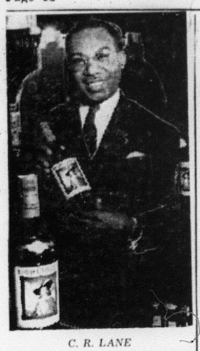
And the Booker T. Washington Hotel, of course. It was opened by a William Bush in August of 1951, taking over from the former Edison Hotel at that location, but sporting an expensive remodel and a new cocktail lounge, the Emperor Room. The hotel was ably managed by C. R. Lane, an Oklahoman who’d been working his way up in hospitality since leaving the shipyards.
Jacqueline Chauhan, who spent time at the Booker T. as a child when her mother was employed there, recalls encounters with Jackie Wilson and Little Richard. She says that musicians would rehearse at the hotel during the day, sometimes before gigs elsewhere in the neighborhood later that night. Maya Angelou’s mother was a clerk at the hotel.
Not limited to just musicians, baseball player Willie McCovey stayed there, and so did the Harlem Globetrotters.
While the jazz era got underway in the Fillmore, forces downtown were already conspiring to completely redevelop the neighborhood. Across America, cities were looking to see how they could use federal dollars for so-called slum clearance and the removal of “blight”. The Western Addition was targeted for the first, and most substantial, of San Francisco’s such projects, and two phases were proposed: A-1, designed to widen Geary St into an expressway and create the all-new Japan Center; and A-2, which would level the rest of the area to replace aging Victorians with new cooperative living complexes, and the Fillmore Street strip with a new commercial center.
A-1 began execution in the 1950s and and was completed first. A-2 was larger, but was approved with minimal community input by 1966. Sixty blocks were cleared. Some Victorians considered worth saving were physically moved around. And everyone was displaced, some temporarily, most permanently. Those who did return, in some cases went from being small property or business owners bought out by eminent domain, to being merely renters in their old neighborhood without the equity they’d worked for.
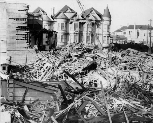
The Fillmore Street commercial district itself was demolished in about 1970, and the blocks left vacant while intended centerpiece Fillmore Center went through development challenges. The destruction of the heart of the neighborhood without immediate rebuilding meant the end of the flourishing cultural and commercial center of gravity there. And swept away with that swath of destruction was the Booker T.
Let’s see if we can find it.
The address of the Booker T. was 1540 Ellis Street, said to be just off Fillmore. The city map today indeed indicates that the 1500 block of Ellis would connect Webster and Fillmore. But that block of Ellis doesn’t sound familiar because it doesn’t really exist except for a small stub turnoff from Fillmore St. making an entrance to the Safeway parking lot:

This image implies the Ellis right of way is mangled from the original city grid in addition to not running through.
How can we determine where in the block number 1540 would have been? We can ballpark it based on the number (north side, near the middle) but that’s not necessarily right. We’ll need a map that has street numbering on it. Here’s a Sanborn Fire Insurance map that was accurate as of about 1950:
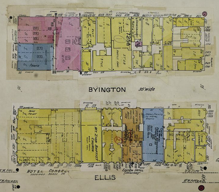
This map shows the block bounded by O’Farrell, Webster, Ellis, and Fillmore, in about 1950 or so. See the one building shaded a brown color in the bottom half? That’s the Booker T. It’s marked with the address but also more obviously marked as the Edison Hotel, its former name. So now we know approximately where the hotel would have been on the block. (Note too Byington Alley, also long gone, that split the block — perhaps musicians loaded equipment at the rear of the hotel on the alley?)
We can match this to a 1938 aerial image of the city. Here’s that same block, with the hotel indicated:
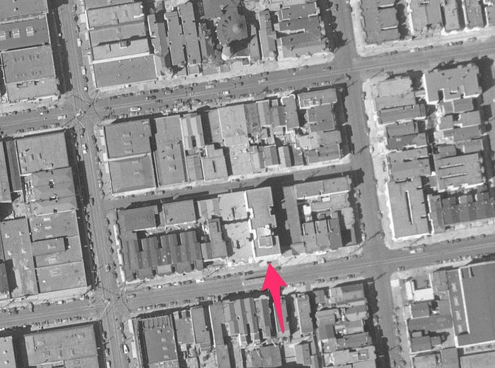
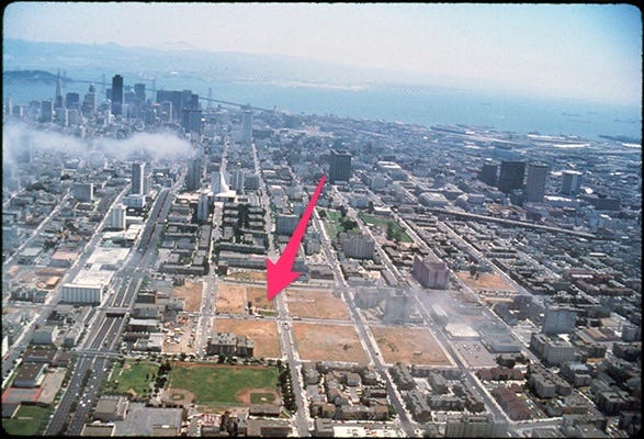
Here’s another aerial view, looking east towards downtown, from sometime in the 1970s, showing the vanished Fillmore commercial district. The new Geary Expressway is visible running up the left of the image, but the original street grid is still there. This deserted scar on the neighborhood lasted for over a decade. The arrow points to the location of the Booker T.
Finally, let’s align the current Google satellite view with the 1938 aerial, and see where the footprint of the hotel would be today:

And there you have it. The old Booker T. Washington Hotel was entirely contained within what is today the Safeway grocery store on Webster. The Safeway and its vast parking lot (which obliterated both Byington Alley and a block of O’Farrell Street) were built in 1983. The hotel’s ground floor sat on a series of the aisles in the Safeway. The front door of the Booker T. would have been several feet behind this blank wall in the Safeway loading dock, which itself sits on the former Ellis St right-of-way:

Tracking the ghosts of the past is one way of understanding how we got to the present. The redevelopment of the Fillmore was in its best intentions terribly misguided, and at its worst a careless racist travesty. The loss of cultural landmarks like the Booker T. Washington Hotel was a loss for the community at the time and remains a loss for the city, which used to be the center of a music scene rivaled only by New York. The Safeway seems an ignominious ending, although it’s a useful purpose to put the land to. It turns out you can actually still get a bottle of wine or champagne where the Emperor Cocktail Lounge was. Unfortunately the music there is just never going to be the same.

Selected sources and further reading
- Jacqueline Chauhan’s recollections about the Booker T.
- Harlem of the West project/book.
- Walter Thompson’s magisterial pair of articles detailing the history of urban redevelopment in the Western Addition: Part 1, Part 2.
- The T-RACES project at University of Maryland has an interactive redlining area map with HOLC documents.
Ben Zotto is a historian with the Hayes Valley Neighborhood Association. This material was researched for a meeting of the HVNA in December 2020. Text and uncredited photos are copyright by Ben Zotto. You can contact me at my Medium name, at Gmail.